2.2 The TUFLOW Modelling Concept
The fundamental software necessary for building a TUFLOW model and viewing simulation results are:
- Text editor. Used to create and edit TUFLOW simulation control files. The control files list all the simulation commands and file path references to the above mentioned GIS and tabular datasets.
- Spreadsheet software. Used for time-series and other non-geographically located data.
- GIS software. Used to create, modify and manage all geographic inputs and to view simulation results.
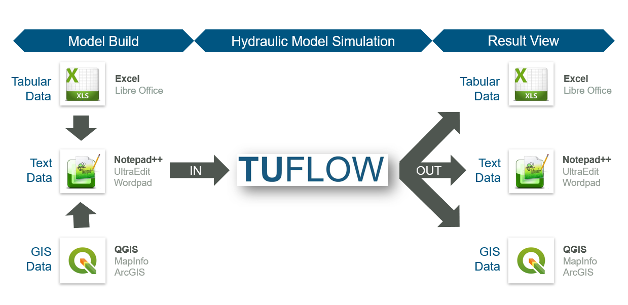
Figure 2.1: TUFLOW Modelling Concept
User survey results consistently indicate that the majority of TUFLOW modellers globally use the text editor / spreadsheet / GIS working environment approach. Within that framework, the most popular supporting software combination is Notepad++, Excel and QGIS (with the free QGIS TUFLOW Plugin). Due to the dominant usage of these supporting software packages, detailed information for Notepad++ and QGIS is provided in Sections 2.2.1 and 2.2.2. Please note, modellers are not required to use Notepad++, Excel and QGIS. Other alternative supporting software may be used instead. A complete list of commonly used options is outlined in Table 2.1. \(\newcommand{\blockindent}{\hspace{0.5cm}}\)
| Software Type | Suggested Software |
|---|---|
| Text Editor |
UltraEdit / TUFLOW Wiki UltraEdit Tips Notepad++ / TUFLOW Wiki Notepad++ Tips Textpad / TUFLOW Wiki Textpad Tips Visual Studio Code Other: Any text editor can be used for creating TUFLOW control files, including the Microsoft Windows default, Notepad. However, the above listed editors are recommended. They allow for advanced options, such as syntax highlighting of TUFLOW control files and launching TUFLOW simulations from the text editor. |
| Spreadsheet Software |
Microsoft Excel / TUFLOW Wiki Excel Tips Libre Office |
| GIS Platforms |
QGIS (TUFLOW Wiki QGIS Tips) with QGIS TUFLOW Plugin. The QGIS TUFLOW Plugin provides a range of pre- and post- processing tools, and dynamic viewing of 1D and 2D results in TUFLOW Viewer. ArcGIS Pro (TUFLOW Wiki ArcGIS Tips) with Spatial Analyst for the creation of model inputs and viewing of static results. Dynamic viewing of 1D and 2D results is not available in ArcGIS. MapInfo Professional (TUFLOW Wiki MapInfo Tips) for the creation of model inputs and viewing of static results. Dynamic viewing of 1D and 2D results is not available in ArcGIS or MapInfo. QGIS (TUFLOW Wiki QGIS Tips), SMS (TUFLOW Wiki SMS Tips) or WaterRIDE are recommended to address these limitations. |
| Other Software |
Scalgo (TUFLOW Wiki Scalgo Tips) FEWS |
For modellers preferring to work predominantly within a Graphical User Interface (GUI) environment instead of GIS, the following TUFLOW GUI options are also available:
2.2.1 Notepad++
Notepad++ is a free text editor available from https://notepad-plus-plus.org/downloads/. The Notepad++ functionality listed below makes it well suited as an editor for creating and updating TUFLOW control files. Click on the respective TUFLOW Wiki links in each bullet point for more information:
- Syntax Highlighting: Colour coding of TUFLOW control files, shown in Figure 2.2.
- Simulation Execution: The ability to start a TUFLOW simulation directly from Notepad++.
- File Navigation: The ability to open files based on the relative reference provided in a TUFLOW control file. For example a geometry control file (.tgc) can be opened directly from the TUFLOW control file (.tcf) without having to locate it in Windows Explorer.
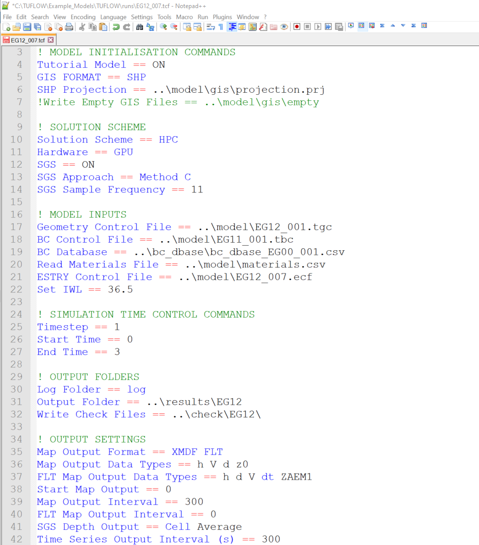
Figure 2.2: NotePad++ TUFLOW Syntax Highlighting
2.2.2 QGIS / TUFLOW Viewer
QGIS is free, open source GIS software available from https://www.qgis.org/. It is an official project of the Open Source Geospatial Foundation (OSGeo). It runs on Linux, Unix, Mac OSX, Windows and Android and supports numerous vector, raster, and database formats and related functionalities.
For users wishing to adopt QGIS as the model development or result viewing environment, we strongly recommend completing our free Introduction to QGIS for TUFLOW eLearning. It teaches how to configure QGIS for TUFLOW modelling and provides an entry level overview on how to use the software.
We also recommend installing the free QGIS TUFLOW Plugin. The QGIS TUFLOW Plugin includes a suite of tools built to increase TUFLOW workflow efficiency. Installation and use instructions are provided in the QGIS Tips and Tricks section of the TUFLOW Wiki Installation of Plugin.
TUFLOW Viewer is included in the QGIS TUFLOW Plugin. As the name suggests, TUFLOW Viewer upgrades the QGIS Map Window to become a complete dynamic interactive TUFLOW simulation result viewer. This addition to QGIS makes the the programme’s functionality comparable to commercial GUI software. Documentation of the TUFLOW Viewer is located on the TUFLOW Wiki TUFLOW Viewer.
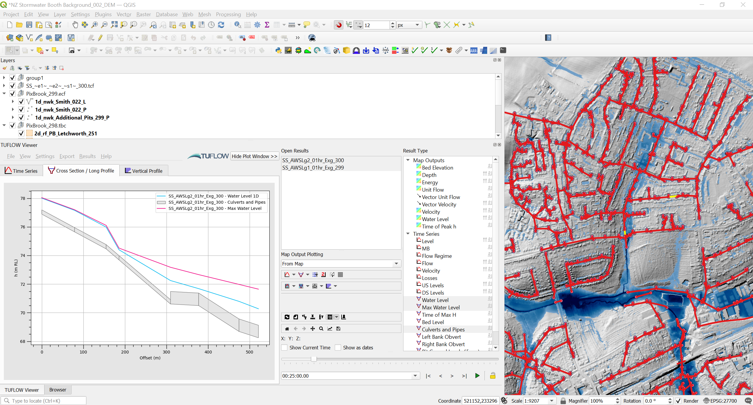
Figure 2.3: QGIS with TUFLOW Viewer