8.7 External Stress Boundaries
The external stress control file (.tesf) allows the definition of time varying global or spatially varying external forcing such as wind or wave radiation stresses. This allows the user to specify one of the following types of wind / stress boundary:
- Global wind (i.e. temporally but not spatially varying wind field is applied).
- Grid Interpolation. Point winds are applied at locations within / near the model, these point winds are interpolated to gridded stresses across the model.
- User specified time varying gridded datasets.
The wind time-series curve is entered as three columns of data (using Column 1, 2 and 3 labels in the bc_dbase). The three columns are:
- Time (h)
- Wind (m/s or ft/s if using
Units == US Customary )
- Direction (degrees relative to East, i.e. East = 0º, North = 90º, etc.).
Prior to the simulation the wind boundaries are converted into a shear stress boundary and this shear stress is applied to the model. The shear stress is calculated based on Equation (8.2).
\[\begin{equation} \tau = C_{10}\ \rho_{air}\ U_{10} \tag{8.2} \end{equation}\]
Where:
- \(\tau\) = shear stress in N/m2 (or lbf/ft2).
- \(ρ_{air}\) = density of air in kg/m3 (or lb/ft3).
- \(U_{10}\) = wind velocity at 10m above the mean water surface in m/s (or ft/s).
- \(C_{10}\) = wind stress coefficient and is calculated using Equation (8.3) based on J. Wu (1980) and J. Wu (1982).
\[\begin{equation} C_{10} = \left( 0.8 + 0.065\ U_{10} \right)\ \times 10^{- 3} \tag{8.3} \end{equation}\]
Note: Metric (SI) units are TUFLOW’s default. To use imperial units, ensure
For the interpolated stress grids, these are output to disk at model start-up and then loaded in during the model simulation as required. The grids can be used as a “check” file as they are written prior to the simulation starting. For each time in the specified boundary series two stress grids are produced, shear stress in the x direction (\(\tau_x\)) and shear stress in the Y direction (\(\tau_y\)). When interpolating grids from point data the wind boundary at each point is converted to \(\tau_x\) and \(\tau_y\) and these x and y component stresses are interpolated using the selected method (as described below).
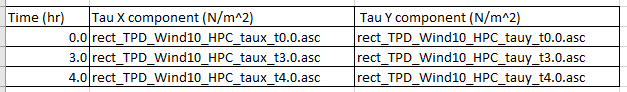
Alternatively, a series of \(\tau_x\) and \(\tau_y\) grids can be directly read into the simulation. The input grids must be in a format TUFLOW supports for reading (see Section 4.3.1). For all formats except NetCDF, an index .csv file is input containing the time data in Column 1, and the filenames for the x and y component stresses in Columns 2 and 3 respectively. For the NetCDF format, time, \(\tau_x\) and \(\tau_y\) must all be variables in the same NetCDF file. The format of the user specified external grids is the same as produced by TUFLOW when interpolating from points to grids.
As the user specified gridded stresses are applied as a stress term (rather than a wind boundary) these could potentially be used for external stress forcing other than winds, for example wave radiation stresses.
All stress related commands (see Appendix G) are specified in the External Stress File (.tesf), which is referred to in the .tcf using the command, External Stress File. If this command is included TUFLOW automatically invokes the external stress functionality. Other .tcf commands relevant to the wind stress functionality are Density of Air, Density of Water, Wind/Wave Shallow Depths. A model using an External Stress File (.tesf) is provided in the Boundary Condition Options Example Model Dataset on the TUFLOW Wiki.
In the .tesf one of the following commands is required to apply global, interpolated from point or gridded stresses.
- Global Wind BC: Used to invokes a global wind boundary.
- Read GIS Wind Point and Read GIS Wind Poly invokes grid interpolation.
- Read Gridded Tau invokes the use of a user specified grid.
If applying a global wind boundary, no additional .tesf file commands are required.
For the grid interpolation the following commands are applicable:
- Grid Interpolation Method
- Output Grid Format
- Output Grid Cell Size
- Output Grid Origin
- IDWExponent
- IDW Maximum Distance
- IDW Maximum Point
The GIS attribute format associated with the inputs called by the Read GIS Wind Point and Read GIS Wind Poly commands is provided in Table 8.15.
| No | Default GIS Attribute Name | Description | Type |
|---|---|---|---|
| 1 | Name | The name of the BC in the BC Database (see Section 8.5). | Char(100) |