Changelog for TUFLOW Plugin v3.12
New Features and Enhancements
TUFLOW Styling
Support Geometry Specific QML Styling
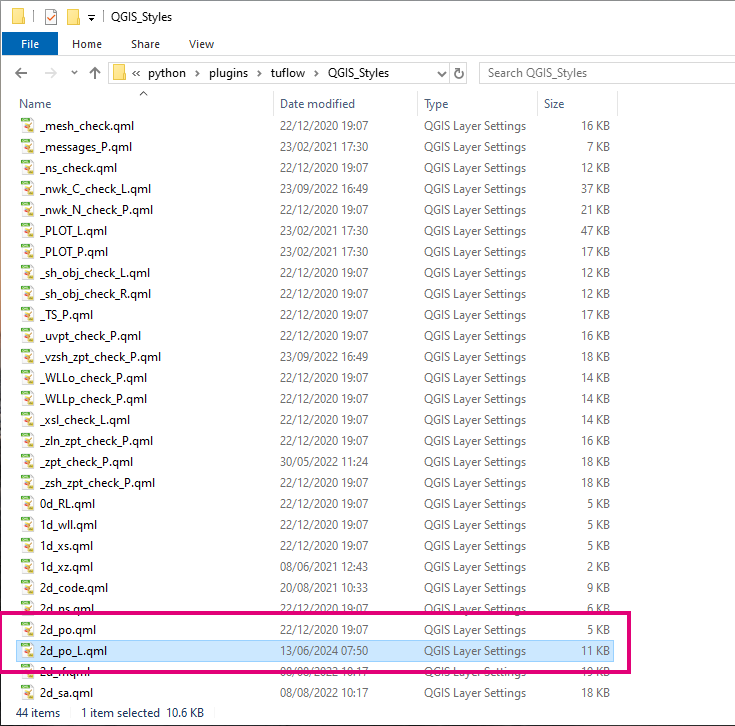
Adds support for users to update the default TUFLOW styling by adding geometry specific QML files. The tool will first search for QML files that contain a geometry extension (_P, _L, _R) before falling back to finding a standard match.
Example:
Input layer: 2d_po_001_L.shp
The tool will first search for a QML file with the name 2d_po_L.qml before searching for 2d_po.qml.
For more information on customising styles, please see the following wiki page:
wiki.tuflow.com/QGIS_TUFLOW_Styles
SWMM Processing Tools
BC - Convert Non-Outfall SX Connections to HX
New processing tool that converts SX connections to non-outfall nodes to HX connections as required by TUFLOW-SWMM. This tool is especially useful after converting a model from XPSWMM or similar that uses SX connections at these nodes.
Convert - XPSWMM Model from XPX (beta)
This tool converts a model from XPSWMM to TUFLOW-SWMM using an xpx file and the TUFLOW tcf file from the XPSWMM simulation. The xpx file can be exported from the XPSWMM application or using the free XPSWMM Viewer. The TUFLOW tcf file is generated when the model is run (analyze from XPSWMM) and is in the “2D\Data” folder unless custom folders were specified.
The output of the tool is a TUFLOW-SWMM model with links to the SWMM inp file.
The tool documentation includes more details on how to use the tool.
Scenarios - Extract from GPKGs
This tool converts multiple standalone TUFLOW-SWMM GeoPackage files into a series of files represented by scenarios generating a common GPKG and one for each scenario. The scenario GPKG files only contain new or modified features from the common GPKG. This makes it easy to see what changes between scenarios and to modify common features without having to change every scenario. This tool also creates a text file with the commands to read the correct input files (inp) by scenario.
Minor Change to the Tool Outfalls - Fix Multiply Connected Links
SWMM does not allow multiple links to connect to the same outfall node. This tool fixes such issues by moving the outfall node and creating a new conduit connecting the original node to the new outfall. Instead of creating a rectangular channel, this tool now uses a dummy channel instead. This eliminates any energy losses or attenutation that may occur when using a rectangular channel.
ARR to TUFLOW
Adds New Methods For Estimating Initial Losses < 60 min
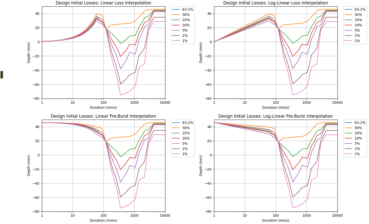
New methods have been added for calculating/estimating initial losses for storm durations less than 60 minutes. This includes interpolating the pre-burst depth values to zero at 0 min (as opposed to the initial loss). Log-linear interpolation methods have been added for both the loss and pre-burst interpolation methods as well. The new methods are listed below, for more information please visit the ARR to TUFLOW TUFLOW Wiki page.
- Log-interpolate to zero - will use a log-linear interpolation (duration will use a log scale) (assuming a loss value of 0 mm for 0 min)
- Interpolate pre-burst - will linearly interpolate pre-burst depths (rather than losses) (assuming a depth of 0 mm for 0 min)
- Log-Interpolate pre-burst - will use a log-linear interpolation on the pre-burst depths (duration will use a log scale) (assuming a depth of 0 mm for 0 min)
Adds Option to Use Design Burst Temporal Pattern Number for Preburst
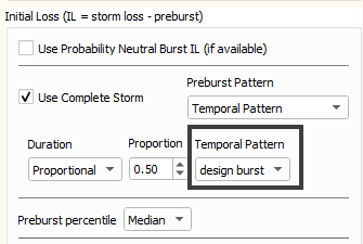
A new option “design burst” has been added for complete storm generation that will use the same temporal pattern number for the pre-burst that is being used for the design burst. For more information please visit the ARR to TUFLOW TUFLOW Wiki page.
Handles Missing ARF Parameter Data
If the ARR datahub download is missing ARF parameter data, the tool will no longer error and will continue with the assumption that the ARF = 1.0. A warning will be added to the output log file.

Processing Toolbox
Create TUFLOW Project Now Creates “Project Home” in Browser
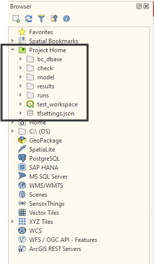
The Create TUFLOW Project tool will now create the “Project Home” shortcut in the Browser panel.
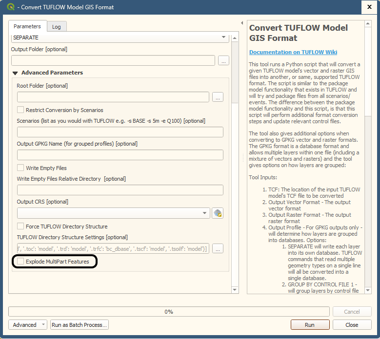
Convert TUFLOW Model GIS Format Supports “Explode Multi-Part Features” Option
The Convert TUFLOW Model GIS Format tool now supports a user setting to explode multi-part features into separate features. Prior to v3.12 this would be on by default with no option to change it. In v3.12 the default has been changed to off.
Import Empty
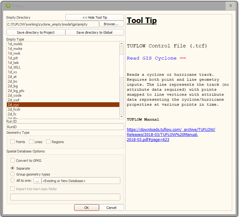
Adds New Empty Tooltips
Adds tooltip for:
- 2d_cyc
- 2d_ad_ic
- 2d_ad_md
- 2d_sa_po
- 2d_strm
Bug Fixes
TUFLOW Viewer
- Fixes a bug related to the upgrade to Python 3.12 that ocurred when switching between plot and narrow views
- Load results from TLF will now ignore encoding errors
Other
- Filter Message by Code - Fixes bug that could cause a python error
- Arch Bridge Editor - Fixes bug that would not let user create a new 1d_xs with the message
Error finding existing cross-section - please try selecting "-None-" - Arch Bridge Editor - Fixes bug when selecting ‘Overwrite’ or ‘Append’ output options that would error saying it could not edit the layer because it was “open” in the workspace.
- pytuflow - Fixes issues if pytuflow is installed where it can become tanlged with the ‘tuflow’ plugin.
- Increment Layer - Fixes bug that would not supersede GPKG layers unless ‘Preserve Database’ spatial database option was selected (only supersedes if there is only one layer in the database)
- Increment Layer - Fixes bug when superseding layers that could sometimes fail due to QGIS holding a lock on them. Fixed for Shapefiles but not necessarily for GPKGs as a lock can sometimes persist until QGIS is closed.
- ARR to TUFLOW - Fixes warning messages that could be reported after running the tool in an error dialog (only appeared for Python 3.12)
- ARR to TUFLOW - The “Unique Catchment Identifier Field” will now automatically default to any field that is called either “name” or “id” (rather than the first field)
- ARR to TUFLOW - Reprojects from easting/northing to long/lat EPSG:4326 rather than EPSG:4203 - can result in different data being extracted if site is bordering hydrological regions.
- Increment Layer (context menu) - fixes a bug that could cause “OGR unrecognised driver ‘’” which could occur after loading the given layer using ‘Load from TCF’
- Increment Layer (on the toolbar) - fixes a bug that was incorrectly setting up the dialog for GPKG layers.
- Import Empty - Fixes a bug if the text
_emptyappeared in the file path (other than in the actual file name) the tool would not correctly identify the available empty types - 1D Integrity Tool - Fixes GPKG inputs in “Channel ID” tool which could cause Python error
- Convert TUFLOW Model GIS Format - Fixes a bug when using convertering TRD files and ‘force TUFLOW directory structure’. Previously file paths referenced in the TRD would be incorrectly referenced based on the TRD file location rather than the calling control file.
- Convert TUFLOW Model GIS Format - Now considers
_TUFLOW_Override.tcffiles when converting models. - Convert TUFLOW Model GIS Format - Correctly interprets and converts MIF projection strings (e.g.
MI Projection == CoordSys Earth Projection ...) - Copy TUFLOW Command - Fixes bug where the ‘TUFLOW’ context menu was not available for MIF layers.
- Apply Label to Current Layer - Fixes a bug where the auto labelling can produce a python error due to changes in API in QGIS versions later than 3.26