Changelog for TUFLOW Plugin v3.11
QGIS will be updating to Python 3.12 in an upcoming release. We are not sure on the exact release version, although users using OSGeo4W may notice that their Python version will be updated to v3.12 next time they run an update. This has the potential to break some functionality in the TUFLOW plugin. This release addresses as many of these instances as possible i.e. where it has currently been found to break. Please contact support@tuflow.com if you encounter any problems.
New Features and Enhancements
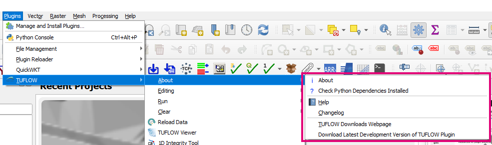
About Menu
The “About” menu now has several useful links including:
- A link to the TUFLOW Plugin wiki documentation
- A link to this changelog
- A link to the TUFLOW downloads webpage
Arch Bridge Editor
Cross-Section Settings
Cross-section settings have been added similar to the bridge settings.

Launch TUFLOW Runner
The TUFLOW runner is now bundled with the QGIS plugin and can be launched from the “Run” menu. The TUFLOW Runner manages a queue of TUFLOW and TUFLOW FV simulations running them as simulations finish and resources are available. The runner supports scenarios and events as long as they use the standard naming conventions (~s1~, ~s2~, etc for scenarios and ~e1~,etc for events). The scenarios and events used for a specific tcf file are remembered for the next time simulations are added to the queue. The queue can be reordered to manage priorities and running simulations can be terminated as needed.
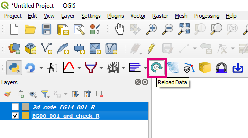
Reload Layer
Reload All Selected Layers
The reload layer tool now reloads all selected layers in the Layers Panel rather than just the what QGIS sees as the ‘active layer’.
SWMM Junction Nodes to Storage Nodes
A tool has been added to convert SWMM junction nodes at HX connections to storage nodes (typically embankment culverts). Storage nodes are recommended in this situation because HX 2D cells do not represent storage so the storage needs to be represented in the connected 1D node. This configuration also provides improved model stability.
SWMM Convert - XPSWMM Hydrology Processing Tool
Portions of the SWMM hydrology data can be exported from XPSWMM as an EPA SWMM file (which can be read in as a GeoPackage file), GIS nodal data (which contains most of the parameters), and GIS subcatchments. This tool uses the GIS subcatchments to match up the nodal subcatchment data and add it as extra columns to the EPA SWMM GeoPackage subcatchments layer. These attributes can then be copied to the relevant parameters.
SWMM GeoPackage Layers Replace Features (from right click menu)
A right-click item has been added to replace the features in a layer with another layer with compatible geometry and attributes. Because TUFLOW-SWMM GeoPackage files are managed as a group of layers rather than individual layers, it is often desired to replace the features from a layer with another layer. This is particularly true after running some of the processing tools. The field values are copied based on field names.
SWAN GIS Tools
The plugin has been updated to use the latest version of the SWAN GIS tools (v0.0.5).
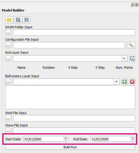
Date Format
The Model Builder date format has been updated to enforce the use of “dd/mm/yyyy” regardless of system settings.
Support for Linux and Mac OS
SWAN GIS Tools have been updated to support Linux and Mac OS builds.
Bug Fixes
TUFLOW Viewer
- Fixes plotting velocity vectors on curtain plots
- Fixes bug when loading NetCDF time series files using a QGIS install without the NetCDF4 library
- Loading multiple TPC files will only bring in one set of GIS layers (back to previous behaviour - new behaviour was not intended)
- Fixes small display bug where units were being dropped from the y-axis on the cross-section plot when culverts/pipes were present.
Processing Tools
- Fixes for the SWMM “GeoPackage - Create from SWMM inp” tool. Handle normal depth outfall nodes and ignore non-readable characters from inp file
- Create TUFLOW Project - Fixes incorrect ECF reference in the generated TCF.
- Convert TUFLOW Model GIS Format - Fixes a bug that would not correctly process spatial database commands in the TCF in the first sweep of the TCF (this can influence things like finding the model projection and writing empty files)
1D Integrity Tool
- A number of bugs pertaining to GPKG have been fixed. The tool should now be fully compatible with GPKG, please let us know (support@tuflow.com) should you encounter any issues using GPKG layers in this tool.
Other
- Arch bridge editor - Fixes bug that could cause error when creating new 1d_xs layers
- Arch bridge editor - Fixes bug where the orifice flow switch was not being turned off in 1d_nwk layer when using ‘Overwrite existing items’ option.
- Arch bridge editor - Updates the default the orifice transition zone depths to 0.1
- ARR to TUFLOW - Fixes Python error that could occur when using the 40,000km2 areal temporal pattern and the 168hr duration. This compbination only has one areal temporal pattern available, the tool will now use the 20,000km2 (the next closest) areal temporal pattern to fill in gaps.
- Configure TUFLOW Project - Fixes a bug in the create empty step that was causing the tool to no longer run TUFLOW correctly to create empty files.