Changelog for TUFLOW Plugin v2026.1.0
Release date: 28 August 2026
- General Notes
- New Features and Enhancements
- Lazy Load Spatial Index
- TUFLOW FV Browser Support
- TUFLOW FV Toolbox - Create Project
- 1D Long Plot Toolbox
- TUFLOW Runner - Run Queue Toggle Looks More Like a Toggle
- TUFLOW Runner - Multiple TUFLOW Versions Supported using PyTUFLOW binaries
- TUFLOW CATCH Tooling
- TUFLOW-SWMM Inlet Classification Tool - On-Grade vs On-Sag
- TUFLOW Viewer V2 - Catch Name Changes
- Bug Fixes
- Other
General Notes
The 2026.1.0 is a feature release for the TUFLOW Plugin. It introduces several new features and enhancements for TUFLOW FV, including browser support and the create TUFLOW FV project tool. It also has a number of enhancements to the TUFLOW Runner and TUFLOW SWMM tools, among other new tools and enhancements.
The 2026.1.0 release also merges in the TUFLOW CATCH plugin. The TUFLOW CATCH plugin was previously a separate plugin and publicly available, however not on the QGIS plugin repository. The TUFLOW CATCH plugin was a temporary plugin to provide specific tools for TUFLOW CATCH users, however with the advent of TUFLOW Viewer V2 (which supports TUFLOW CATCH results) the plugin has been merged into the TUFLOW Plugin. The merge means that only one plugin is required for TUFLOW users as well as only one plugin to maintain from a development standpoint. The TUFLOW CATCH plugin has now been deprecated, it is still available, but no longer maintained (and will not be ported to QGIS 4.x).
New Features and Enhancements
Lazy Load Spatial Index
TUFLOW Viewer V2 will now lazy load the spatial index. For large mesh datasets (>1 GB 2dm files), this will greatly improve the mesh load time (almost half the time it takes to load the mesh). The cost is moved to the first time the spatial index is required, which is typically when plotting from the mesh result. This means that the first time a plot is generated it can take significantly longer as the spatial index is required to be generated. For large 2dm files, this can be in the order of >30 sec (depending on hardware). Subsequent plots will be much faster as the spatial index is cached in memory.
The speed improvements refer to the mesh load time only, and not the time it takes for QGIS to render the mesh which can be significant for large meshes (especially the initial render).
TUFLOW FV Browser Support
TUFLOW FV control files are now supported in the QGIS Browser Panel. This allows FV control files to be expanded and GIS layers to be seen and added to QGIS. The browser model uses a tree structure, which means that any control files referenced in a given FV control file can be expanded and the GIS layers in those control files can also be seen and added to QGIS.
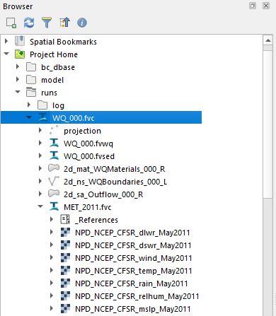
Dragging the
.fvcfile itself into QGIS is not supported yet.
Other features of the FV browser support include:
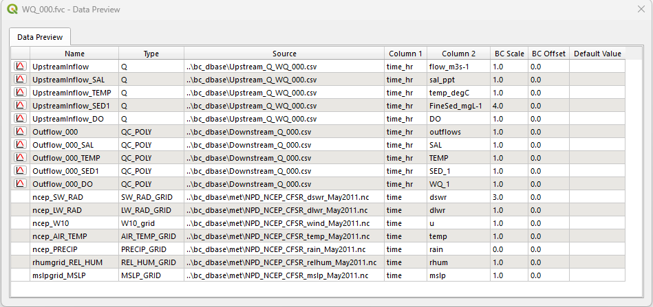
- Generating a boundary database from an FVC file (via the right-click context menu) which will collate and list the boundaries within the model. The boundaries can be plotted by clicking the plot icon to the left of the boundary name.
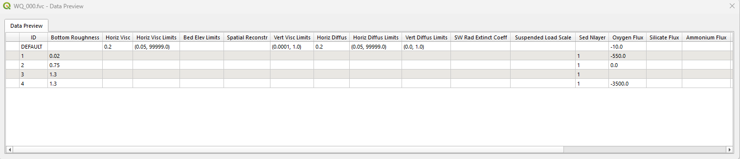
- Generating a material database from an FVC file (via the right-click context menu) which will collate and list the materials within the model.
- Apply a run filter and highlight missing files as per the TUFLOW HPC/Classic browser support
TUFLOW FV Toolbox - Create Project
Experimental
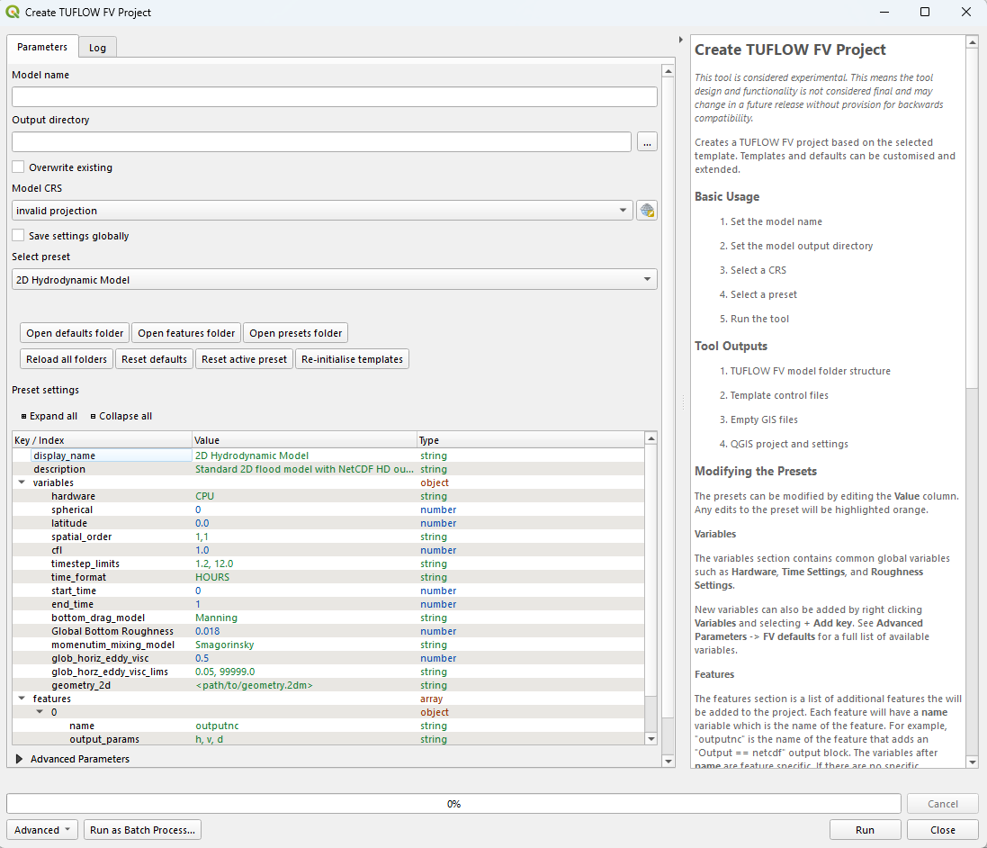
A tool has been added to the new TUFLOW FV toolbox that creates a new TUFLOW FV Project. The tool is similar to the TUFLOW Classic/HPC Create Project tool, however has the option for several presets templates and exposes a lot more project settings.
For example, the user can select the template for “2D Hydrodynamic Model” or “3D Particle Tracking Model” (among others). These templates will have different default settings for the project, which the user can edit or extend.
The tool is built on the pytuflow-project cli, which is highly customisable. These customisations are also applicable to the TUFLOW FV create project tool. For more information on how to customise the project templates, see the pytuflow-project documentation (no Python experience required).
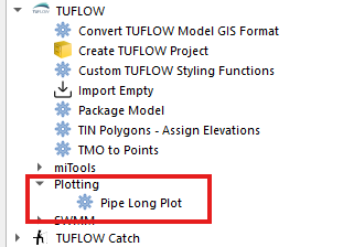
1D Long Plot Toolbox
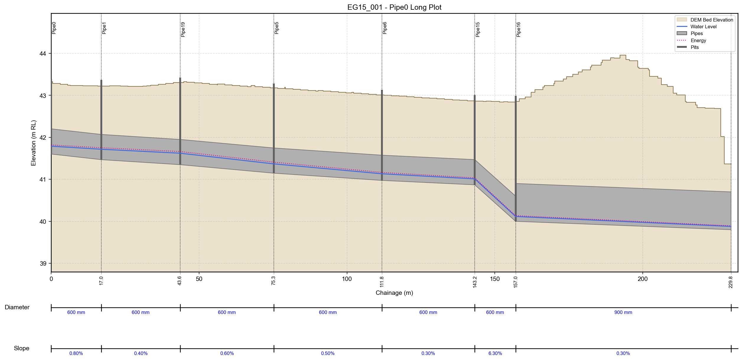
A new 1D long plot tool has been added to the TUFLOW Plugin toolbox. This tool produces a static image of a 1D long plot from a TUFLOW simulation. The tool differs from long plots generated by TUFLOW Viewer in that it produces a more polished plot with extra information for pipe long plots e.g. the inclusion of a DEM and labelled pipe size and slopes.
The tool also offers extensive styling customisation.
The plotting functionality may be moved to TUFLOW Viewer V2 in the future, but for now it is available in the TUFLOW Plugin toolbox.
TUFLOW Runner - Run Queue Toggle Looks More Like a Toggle
Previously, the run/pause button was a simple button which was hard to identify that it was a toggle and what state it was in.
Now, when the toggle is “on” it looks like this:

If the toggle is “off” it looks like this:

TUFLOW Runner - Multiple TUFLOW Versions Supported using PyTUFLOW binaries
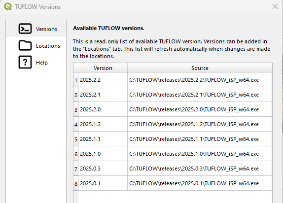
When adding simulations to the run queue, the selected version will be used to run the simulation. It is possible to have simulations in the queue that will be run in different versions of TUFLOW.
The version information is stored with PyTUFLOW and is therefore shared with other uses of PyTUFLOW including the QGIS plugin itself. If the versions are updated outside the runner, they can be refreshed by going to the settings dialogue.
TUFLOW CATCH Tooling
The TUFLOW CATCH plugin has been merged into the TUFLOW plugin. Many of the tools within the plugin were duplicates of tools within the TUFLOW plugin (such as tools to style layers and import empty files). These tools have not been duplicated, and only tools that are unique to the TUFLOW CATCH plugin have been added to the TUFLOW plugin.
The result plotting functionality of the TUFLOW CATCH plugin has not been brought across. This is because the TUFLOW Viewer V2 supports TUFLOW CATCH results and is a more robust and feature rich result plotting tool.
The TUFLOW CATCH plugin has now been deprecated, it is still available, but no longer maintained (and will not be ported to QGIS 4.x).
As part of the merge, various enhancements have been made to the TUFLOW CATCH tools, including:
- TUFLOW CATCH Import Empty processing tool has been updated to be more similar to Import Empty. Updates include:
- Tooltips are displayed for the empty files
- Geometry type(s) are selected when selecting the file type
- The tool dialogue has been updated with further information
- Added sample horizontal hydraulic conductivity values to the TUFLOW CATCH
_soils.tsoilftemplate file. - Copy TUFLOW Command option has been added for TUFLOW CATCH files,
2d_rpand2d_im
TUFLOW-SWMM Inlet Classification Tool - On-Grade vs On-Sag
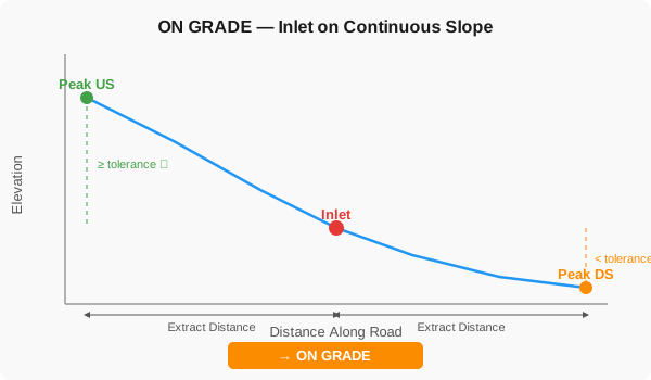
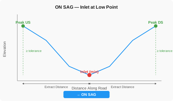
A new processing tool has been added that automatically classifies stormwater inlets as on-grade or on-sag. It projects each inlet onto the nearest road centreline, samples DEM elevations along a gutter line upstream and downstream, and classifies based on whether elevations rise on both sides of the local low point or just one. Outputs include a tagged SWMM inlet usage layer with 1D/2D connections at on-sag inlets, a TUFLOW-SWMM 2d_bc layer for on-grade approach flow, and QA layers (elevation extraction statistics and profiles) for easy engineer review.
TUFLOW Viewer V2 - Catch Name Changes
TUFLOW Viewer V2 will now catch when the user updates a result layer name in the QGIS Layers Panel. The change will be reflected in the plot window.
Some results will not have their name change propagated to the plot window. Typically, these are the results that have multiple GIS layers associated with them, or the GIS layer name does not match the result name. For example, TPC results, which use multiple _PLOT_ layers.
Bug Fixes
- TUFLOW Viewer V2 - Implemented better error messaging if the user gets a “Permission Denied” error when trying to open a NetCDF result.
- TUFLOW Runner - Fixed a bug that caused a Python error when opening the Settings window or starting the run queue on Linux because the numeric settings, such as the GPU count, were read as text.
- TUFLOW Runner - Fixed a bug that caused simulation files in the Runner dropdown to appear in a non-alphabetical order on Linux.
- Run TUFLOW Simulation - Fixed a bug that caused a Python error when allowing the tool to capture output and the TUFLOW standard output contained a non utf-8 character. The tool will now ignore non utf-8 characters in the output.
- Import Empty - Fixed a bug that could cause a Python error when trying to import an empty file that was a different GIS type to the type the project was created with (via the Create Project tool) e.g. import a
.shpfile when the project was created with the.gpkgGIS type. - Import Empty - The import empty types are now updated when the project/empty directory is updated.
- Import Empty - Fixed the Python error that would trigger when clicking “Save settings globally”.
- TCF Browser - Fixed a bug where if a
.prjfile was used in a TUFLOW projection command, and the accompanying shapefiles were missing (i.e. the.shp,.dbfetc), then the projection was not read in correctly and produced a warning. - Load from TCF - Fixed a bug that would cause an error if there was a trailing
|at the end of anIf Scenario == ... command. - SWMM Toolbox - Several bugfixes were made related to the SWMM tool “Convert - XPSWMM Model from XPX”
- SWMM Toolbox - Fixed an error reported in the log with the message “‘pyarrow.compute’ has no attribute ‘match_substring_regex’.” Upgrading the version of PyArrow can resolve this but the plugin will now revert to an older method when this occurs. This change may affect similar issues outside of this tool
- SWMM Toolbox - Fixed a bug where natural transects (cross-sections) have reversed elevation and station data.
- SWMM Toolbox - Handle the situation where multiple transects are written to the xpx file. To mirror XPSWMM, the first instance is used and a warning is given identifying the name of the transects and that multiple transects were associated with it.
- SWMM Toolbox - Fixed an error that could occur if it is not possible to determine a relative path from the tbc file to a GIS BC layer. When this occurs, the full path of the GIS file is now used rather than giving an error.
Other
- Bumped PyTUFLOW Version to
1.2.0