Changelog for TUFLOW 2026.3.0
Release date: 28 August 2026
- General Notes
- Backwards Compatibility
- New Features and Enhancements
- Raster Input/Output Improvements for GDAL Rasters
- Cloud Optimized GeoTIFFs (COG) Write support
- Lower Memory Usage and Faster Raster Reading for GDAL Rasters
- Interpolation Approach Options for GDAL Rasters
- New Water Level Output at SGS Cells under Sheet Flow Conditions
- TUFLOW Classic/HPC User Manual Update
- Bug Fixes
- Other Changes
General Notes
The 2026.3.0 version of TUFLOW Classic/HPC is a feature release and contains a number of new features and enhancements. The new features include the continued development of GDAL integration, which now includes Cloud Optimized GeoTIFFs (COG) write support, and enhanced raster reading performance and memory usage. This release also includes an enhanced water level output for SGS models for cells under sheet flow conditions.
Licensing
- For perpetual licences, running simulations using 2026.3.0 requires payment of the 2026/2027 annual software maintenance fee (invoiced in mid-2026) and that the TUFLOW licence has been updated with the 2026 feature map code (i.e., via RaC/RaU files). For active rental and subscription licences, no updates should be required; however, if you have issues running the latest TUFLOW versions, please contact sales@tuflow.com.
-
Jacobs is a TUFLOW reseller. Historically, TUFLOW software sales processed through Jacobs were supplied with licences issued by Jacobs, using WIBU Firm Codes 10198 and 5000219.
TUFLOW client licences are now fully managed by TUFLOW (BMT). As a result, support for the legacy Jacobs-issued licences has been removed in this release. If Jacobs licence firm codes are specified in the TUFLOW licence settings file (.lcf) using the
WIBU FIRM Code Search Order command, they will be ignored.If you are a Jacobs client and have not yet transitioned to a TUFLOW (BMT) licence, please contact the Jacobs sales team at sales@floodmodeller.com to obtain the necessary licence update.
For any licensing enquiries, please contact sales@tuflow.com, or for general support, support@tuflow.com.
Backwards Compatibility
It is not expected that the 2026.3.0 release would cause changes in results if upgrading from any of the prior 2026.x releases, with one exception noted below.
Users who have started testing the command
Use GDAL == ON (introduced in 2026.0.0) in their models may see some minor differences in2026.3.0. This is due to the fact that the commandUse GDAL == ON will automatically enable the new GDAL interpolation approach in2026.3.0. The interpolation approach used by GDAL, which differs from the TUFLOW interpolation approach, can result in TUFLOW extracting slightly different values from a raster dataset. This can then lead to slightly different results out of TUFLOW.
New Features and Enhancements
Raster Input/Output Improvements for GDAL Rasters
A number of improvements have been made when using GDAL, which are noted in the sections below.
The improvements only apply if
Cloud Optimized GeoTIFFs (COG) Write support
Must be used in conjunction with
Use GDAL == ON
TUFLOW now supports writing Cloud Optimized GeoTIFFs (COG) for check files or grid based outputs. Reading was previously supported (added in 2026.0.0).
Writing COG grids is activated using the existing command:
The command
Lower Memory Usage and Faster Raster Reading for GDAL Rasters
Must be used in conjunction with
Use GDAL == ON
Reading rasters using this approach will generate different values when compared to
Use GDAL == Off , or if comparing results from previous TUFLOW versions. This is due to the interpolation approach used by GDAL, which differs from the TUFLOW interpolation approach (GDAL has no equivalent approach). For existing projects, it is recommended to setUse GDAL == Off to match previously generated results.
TUFLOW is now able to read the extent and resolution of the target grid without additional memory usage. Previously, TUFLOW would have to read the full raster into memory even if the raster extents were far larger than the TUFLOW domain or if the TUFLOW resolution was much coarser than the raster. Now, TUFLOW uses GDAL to construct a virtual raster with the orientation, extent, and resolution required and extract only the values required. This saves runtime and memory usage especially when pulling from large rasters. Because extraction from large rasters can be performed efficiently, it is unnecessary to clip a source raster to improve memory usage or runtime for TUFLOW models.
Interpolation Approach Options for GDAL Rasters
Must be used in conjunction with
Use GDAL == ON
It is now possible to specify the interpolation approach used by GDAL when extracting data from rasters. This controls the interpolation utilised when creating the virtual raster mentioned in Lower Memory Usage and Faster Raster Reading for GDAL Rasters. There are separate commands for float based raster usages such as elevation data and integer based rasters used for material ids, soil ids, and other similar uses.
The command for float based raster usages is:
The GDAL Warp Documentation includes descriptions of the different resampling methods.
Care should be taken when selecting an option other than bilinear (the default), nearest, average, or med(ian). Several of the options use a curve fitting style algorithm that can create artificially high or low elevations including cubic, cubicspline, and lanczos. While the remaining options (max, min, q1, and q3), won’t generate artificial extremes, they are unlikely to be useful when modelling.
The command for integer based raster usages is:
Fewer options are available for these applications as material ids, soil ids, or similar integer uses cannot be interpolated. Mode uses the most common value for the area sampled and can give a better representation than nearest which may capture a value that applies to a very small subset of the area.
The sampling distance for both floats and integers depends on the type of data being sampled. For most applications, the sampling distance is the cell size, whether extracted at cell centres or cell faces. However, for non-SGS elevations the sampling distance is half the cell size and are sampled at corners, centres, and middle of faces. For SGS elevations, the sampling distance matches the SGS sampling distance.
New Water Level Output at SGS Cells under Sheet Flow Conditions
Beta Functionality
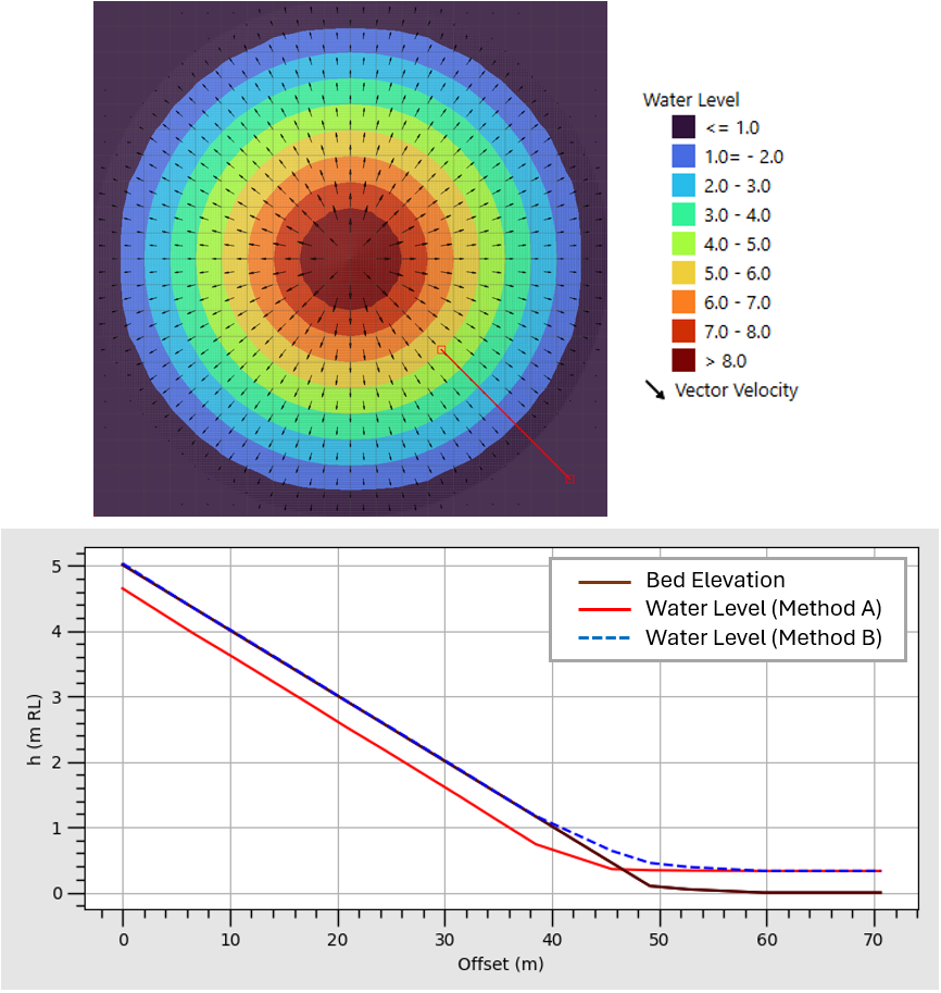
A new method (METHOD B) has been added to output water level based on cell average depth and cell centre elevation when sheet flow conditions occur at any given cell. METHOD A is the default approach and matches the behaviour prior to version 2026.3.0.
METHOD A (the existing behaviour), assumes water fills from the bottom of the SGS cell regardless of hydraulic conditions. This could result in the water level output appearing below the ground when the depth is small. METHOD B (the new option) allows output water level to be presented above the cell centre elevation when a given cell is experiencing sheet flow. This option is particularly useful for presenting water level on steep slopes in direct rainfall models.
The examples below compare water level outputs using METHOD A versus METHOD B in a direct rainfall model over a cone-shaped geometry. METHOD A shows the limitations of the method as water level is shown to be below the ground level. METHOD B presents a much better result with a thin water layer over the bed elevation with a smooth transition of water level to fully wet cells.
Must be used in conjunction with
SGS Sheet Flow Approach == Method B
This is currently only applied to the standard water level output. Other map output data types, such as depth or the high-resolution (HR) water level output, are not affected by this command.
This output relies on the elevation value that occurs exactly at cell centre. The value at the centre could contain an outlier elevation that causes the output to appear artificially high or low. For example, when the model is using a cell size much larger than features in the terrain (such as a road embankment or creek), the elevation in the centre of the cell may happen to fall on this feature. Sheet flow could be correctly triggered for the cell, but due to the elevation at the cell centre being anomalous, the water level output could appear incorrect. As this is currently tagged as beta functionality, it’s important to check water level results for anomalies which could be due to this feature, particularly if the model is using a coarse resolution.
TUFLOW Classic/HPC User Manual Update
The TUFLOW Classic/HPC User Manual has been migrated to a new publishing system based on the Quarto framework. This improves navigation, search functionality and provides consistency with the 2026 upgrade of the TUFLOW FV User Manual, TUFLOW CATCH User Manual and TUFLOW FV Water Quality User Manual.
Bug Fixes
Linux
- Fixed a bug where absolute filepaths with leading spaces could cause an issue on Linux. For example
Log Folder == /home/user/project/tuflow/log was OK, butLog Folder == /home/user/project/tuflow/log could cause issues.
Domain Construction
- Removed the need for at least one groundwater layer when running a TUFLOW CATCH model. ERROR 3704 message has been downgraded to CHECK 3704.
- Fixed a bug in Quadtree where the
Orientation Angle == <angle> command in the.qcfwas not applied correctly. - Improved error messaging for unsupported features in TUFLOW CATCH models. For example, TUFLOW CATCH does not support Quadtree meshes yet, this will now produce ERROR 2683.
- Improved error messaging for unsupported boundary types in TUFLOW HPC AD/CATCH models. The use of QT boundaries now correctly triggers ERROR 4019, while the use of 1D/2D HX boundaries produces ERROR 1463.
1D Network Domains - ESTRY
- Fixed a bug where the hydroprop_check file would not match the inputs when arch bridges were included if outputting to shapefile, in some instances. The issue was related to shapefile attribute sizing so only conditions that exceed the specified size would be affected.
- Fixed a bug that could cause an unhandled Fortran exception where ESTRY channels used a very large positive integer value as a channel ID. These were being converted and stored as a temporary 32-bit integer. However, if the IDs exceed the largest number that can be stored by a signed 32-bit integer variable (2,147,483,647) it caused Fortran “input conversion error”.
Boundaries and Links
- Fixed a bug that could cause an unhandled Fortran exception “unknown unit number” to occur when processing a
.tcfwith events / scenarios in combination with a Rainfall Control File.
Outputs and Check Files
- Fixed a bug where outputting vertical groundwater flux map output could cause a stack overflow error when the model also included AD constituents.
- Fixed an issue where TUFLOW did not give a warning when a PO line geometry had a specified water level (H) output type which only exists on points. WARNING 2476 is now given when this occurs.
- Fixed a bug where the HPC solver incorrectly reported the version as 32-bit when running on Windows. All versions were 64-bit matching the TUFLOW executable, the issue was logging only.
- Fixed a bug where the bed elevations were all zero in WaterRIDE raster outputs (
.wrr) when using Quadtree.
Other Changes
- Removed obsolete console output regarding internal GIS module and WIBU module versions.