Changelog for TUFLOW Plugin v3.10.2
Release date: 14 Mar 2024
New Features and Enhancements
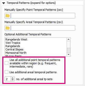
ARR to TUFLOW - Support for More Options for Including Additional Temporal Patterns
Options have been added that allow temporal patterns from different temporal pattern bins to be added to the output. For more information please see the ARR to TUFLOW Wiki Page.

Create Project (Toolbox) - Basic “run.bat” Will Now be Created
The tool will now output a very basic runs/run.bat file when Create Control File Templates is checked on.

Create Project (Toolbox) - GPKG GIS Format Now Adopts Spatial Database Approach
When the GPKG GIS format is selected, the control file templates will now adopt a Spatial Database == template.

Simple TUFLOW Run Tool - Capture Console Output
A setting has been added to the Run TUFLOW Tool to capture the console output in Python rather than creating a new DOS window. The console output is then presented to the user when TUFLOW is finished (or errors). This allows users to check the console text in situations where the console window closes too quickly for the error to be viewed and the TLF has not been created yet.
Bug Fixes
TUFLOW Viewer
- Bug fix to support SWMM 1D GPKG time-series files generated by simulations (tcf filename) which start with a number. Previously, these files would load but plotting would not work correctly.
- Bug fix which was preventing NetCDF rasters from being loaded in Linux (introduced in v3.10.1)
Other
- TUFLOW Plugin - Fixes an issue loading the plugin in older QGIS versions due to an illegal python statement for older python versions
- Convert TUFLOW Model GIS Format - Fixes a bug where output GIS layers were not being given a CRS unless the user had specified one in the input dialog
- Convert TUFLOW Model GIS Format - Fixes a bug when converting a model into a TUFLOW standard directory structure where .qcf was not recognised as a control file
- 1D Integrity Tool - Fixes a bug when a temporary corrected layer is created from a GPKG layer (remove the fid field)
- SWMM Processing tool “Set Junction Atts” improvements - Better messaging if junctions layer is empty and made the conduits layer required.
- Create Project (toolbox) - Adds missing
bc_dbase.csvreference in the TCF control file template.